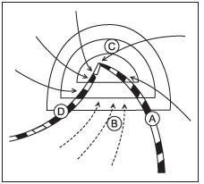
Correct Option (D):
Region D in the given figure represents the area along the advancing cold front of a mid-latitude cyclone. When a cold air mass rapidly undercuts and lifts a warmer, moist air mass, it leads to strong atmospheric instability and intense convection. This forced uplift of warm, moist air results in the formation of towering cumulonimbus clouds. These clouds are responsible for heavy, short-duration torrential rainfall, often accompanied by thunderstorms, lightning, and sometimes hail. This zone is characterized by the most violent weather within the frontal system.
Incorrect Options:
- Option A: This region is typically located within the warm sector of the cyclone, situated between the warm front and the cold front. The weather in the warm sector is generally characterized by warmer temperatures, higher humidity, and often light to moderate, continuous precipitation from nimbostratus clouds, rather than intense thunderstorms.
- Option B: This area represents the central low-pressure region of the cyclone. While it is the core of the system, it does not experience the most severe weather. In mid-latitude cyclones, the central region can have overcast skies and light precipitation, but it is not the primary zone for the intense convection and thunderstorms associated with frontal activity.
- Option C: This region is situated behind the cold front. After the passage of the cold front, the air mass becomes colder and drier. Weather conditions typically involve clearing skies, decreasing precipitation, and colder temperatures, with scattered cumulus clouds. The intense frontal weather has already moved past this area.