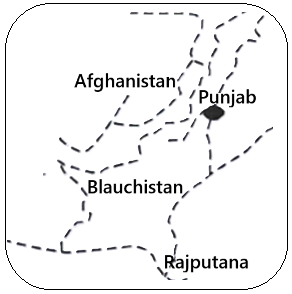
The dotted line on the map represents the Durand Line. This boundary demarcates the border between Afghanistan and the northwestern part of the Indian subcontinent, specifically areas now constituting parts of Pakistan (Punjab and Balochistan). It was established in 1893 by Sir Mortimer Durand, then Foreign Secretary of British India, to define the spheres of influence between British India and the Emirate of Afghanistan. Currently, it serves as the de facto international border between Afghanistan and Pakistan. However, Afghanistan has historically not recognized it as a legitimate international frontier since 1947. The line traverses Pashtun tribal territories, contributing to ongoing geopolitical complexities in the region.
Incorrect Options
The McMahon Line defines the boundary between India and China in the eastern Himalayan region. It is geographically distinct from the area depicted in the map.
The Boundary Commission, led by Sir Cyril Radcliffe in 1947, delineated the partition lines between India and Pakistan, primarily affecting the provinces of Punjab and Bengal. This line does not represent the border with Afghanistan.
The Younghusband expedition was a British military mission to Tibet in 1903-04. Its route is unrelated to the border between Afghanistan and the Indian subcontinent.