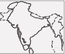
Correct Option (D)
The map depicts the Mughal Empire at its greatest territorial extent, which was achieved under Emperor Aurangzeb. His reign, from 1658 to 1707, saw significant expansion, particularly into the Deccan and parts of South India. By the time of his death in 1707, the Mughal Empire encompassed nearly the entire Indian subcontinent, a territorial peak that aligns with the boundaries shown in the provided map.
Incorrect Options:
Option A: Akbar at the time of capture of Khandesh in 1601
While Akbar significantly expanded the Mughal Empire, including the capture of Khandesh in 1601, the empire's territorial limits at this time were considerably smaller than those depicted in the map. The map shows extensive territories in the Deccan and further south that were not under Mughal control during Akbar's reign.
Option B: Akbar at the time of his death in 1605
By Akbar's death in 1605, the Mughal Empire had expanded considerably, but it still did not include the vast southern territories shown in the map. Significant portions of the Deccan and the far south were yet to be incorporated into the Mughal domain, which occurred primarily under Aurangzeb.
Option C: Aurangzeb at the time of capture of Hyderabad
The capture of Hyderabad (Golconda) by Aurangzeb occurred in 1687. While this marked a significant expansion into the Deccan, the map illustrates an even larger empire, including territories further south that were consolidated later in Aurangzeb's reign, leading up to his death. The map represents the empire at its maximum extent, which was achieved by 1707.