Correct Option
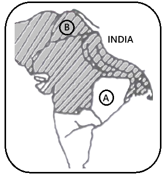
The map illustrates the extent of Akbar's empire by 1605, the year of his death, representing its territorial peak. By this time, the Mughal Empire had significantly expanded across the Indian subcontinent.
A (Gondwana): This region, situated in central India, was integrated into the Mughal Empire as part of Akbar's strategic expansion and consolidation efforts. Its annexation was a notable territorial gain in the central Indian plateau.
B (Lahore): Lahore functioned as a vital administrative, economic, and cultural hub of the Mughal Empire during Akbar's rule. It was a prominent provincial capital and held significant strategic importance.
Incorrect Options
Options 1 and 2 are incorrect because the year 1557 falls early in Akbar's reign (he ascended the throne in 1556). At this juncture, the Mughal Empire's territorial control was limited, and major expansions, including the incorporation of regions like Gondwana, had not yet occurred. Lahore, while important, was not depicted in the context of the empire's full extent at that early stage.
Option 3 is incorrect because while Gondwana was part of Akbar's empire by 1605, the city marked as 'B' on the map is Lahore, not Multan. Multan was also an important city, but its geographical position does not align with the marker 'B' in the context of the given map.