Correct Option
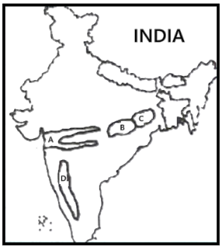
The places marked A, B, C, and D on the map correspond to the Rift Valley region, Chhattisgarh Plain, Chhota Nagpur Plateau, and Rain Shadow region, respectively.
A: Rift Valley Region. This area represents the Narmada-Tapi river valleys, characterized by their formation due to tectonic subsidence.
B: Chhattisgarh Plain. Located in central-eastern India, this region is drained by the Mahanadi River and is notable for its flat topography and extensive rice cultivation.
C: Chhota Nagpur Plateau. Situated primarily in Jharkhand and adjacent parts of Odisha, this plateau is recognized for its rich mineral resources and ancient Precambrian rock formations.
D: Rain Shadow Region. Positioned to the east of the Western Ghats, this area experiences low annual rainfall due to the orographic effect, where moisture-laden winds release precipitation on the windward side of the mountains.
Incorrect Options
Options (a), (b), and (d) present an incorrect sequence or identification of the physiographic regions. Specifically:
Options (a) and (d) misidentify or misplace one or more of the marked regions within the sequence.
Option (b) incorrectly places the Chhattisgarh Plain geographically before the Rift Valley region, which contradicts their actual west-to-east orientation as depicted on the map.