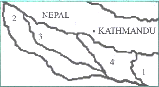
Correct Option (c)
Gandak, Ganga, Gomti, and Ghaghara.
The rivers labelled 1, 2, 3, and 4 on the map correspond to Gandak, Ganga, Gomti, and Ghaghara, respectively, based on their geographical positions and flow patterns in the Indo-Gangetic Plain.
- River 1: Gandak. This river originates in the Nepal Himalayas, flows southward, and enters India in Bihar before joining the Ganga River near Patna.
- River 2: Ganga. This represents the main stem of the Ganga River, flowing generally from west to east across the plains of Uttar Pradesh and Bihar.
- River 3: Gomti. Originating in the Pilibhit district of Uttar Pradesh, it flows through Lucknow and merges with the Ganga near Ghazipur.
- River 4: Ghaghara. Originating in the Tibetan Plateau, it enters India via Nepal and is a significant left-bank tributary of the Ganga, joining it near Chhapra in Bihar.
Incorrect Options
Options (a), (b), and (d) are incorrect because they misidentify one or more of the labelled rivers or present them in an incorrect sequence. For example, Kosi and Teesta are located further east of the depicted region for rivers 1, 3, and 4, making their inclusion or placement inaccurate for the given map labels.